![]()
![]()
![]()
![]()
3. Kielder
start: Kielder Village
distance: 38 miles
OS map: 80
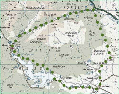 This is quite a long trip so allow plenty of time and try to pick some decent weather - there are some bleak stretches here.
You can start at the Visitor Centre at Kielder Castle. The first part of the route goes along the length of Kielder Water, so there's a choice here. The S side is on road; the N side is on forest track and takes a little longer. From the visitor centre go down the hill. Turn R and go up the hill for the road or turn L and go along past the school to pick up the forestry track. In either event you'll end up at the dam - you can cycle over this if you need to.
We're heading E for Lanehead. Again there's a choice - the road on the N side of the river has some height gain (and loss); the road on the S side less so. For a description of the route on the northern side, see the Black Middens Bastle route.
There's some hard work to come soon. From Lanehead we go N through Greenhaugh and, at a junction near Gatehouse (792 891), turn NE. Steeply up to a T junction at Pit Houses and turn L aiming for the forest where the road becomes a track. Soon you're following the Pennine Way and should arrive at a picnic spot just before the main A68. Turn L to follow the 'forest drive' which leads us towards Kielder Village. There's a long, but not particularly fierce, uphill section to Blakehope Nick - pause for view - and then it's pretty well all downhill to the Visitor Centre.
jb, galashiels
Download GPS data in GPX format.
![]() back
back
![]() next
next
![]() home
home
![]() map and routes
map and routes