![]()
![]()
![]()
![]()
59. Salters Road
start: Ingram
distance: 40 miles
OS map: 80, 81
 This is a superb route going up the Coquet valley then taking you high up into the Cheviots to follow an old trail - Salters Road - over and down into the Breamish valley. Pick a sunny day and enjoy!
Start by a Brandon Ford over the river Breamish on the Ingram road (041 170). Go across the footbridge, or get wet - whichever suits - then head for Branton and on to Mile End Farm. Keep heading south to go past some cottages at Mountain then turn R just after you cross the River Aln.
We're aiming for Alwinton and there are a number of routes. Ours goes past Ryle Mill to Little Ryle where you take a R turn for Alnham. The road from here to Biddlestone has a couple of gates on it but don't be put off. At Rookland the road turns into a track with some more gates to negotiate as it heads along then down to Clennell Hall, passing a campsite on the way. Follow the road now into Alwinton village. The 'Rose and Thistle' has some photocopies of bike routes in the bar, but opening hours seem a little unpredictable.
Follow the road up the valley for six or seven miles until you come to a turning signed for Uswayford. It's a good surface to start with but soon reverts to a track as you head upwards. The views start to open up with the Border Ridge and Windy Gyle to your L and Kidland Forest over to the R.
Don't go as far as Uswayford but, instead, look for a turning into the forest at (878 141). This is a good track with open views as it contours around the head of a valley for about 4 miles. Just before where the track ends at a turning area, you'll pass wooden signs indicating where Salters Road goes off to the L and to the R. Take the track on the L and follow it over softish ground to reach a gate at the watershed (905 157). Again the views here are extensive in all directions. This is magnificent country; savour it.
The best line keeps well to the L of the watercourse and goes steeply down then round to the L improving as we go. Cross the stream then re-cross by a small bridge. The track is a good one now and passes High Bleakhope to swing L at Low Bleakhope.
The road climbs, then drops down to Alnhammoor before climbing again to join the 'main' road. From here it's a real breeze down the valley to Ingram. Have a look at the Visitor Centre while you're there.
jb, galashiels
Download GPS data in GPX format.
Coquet Valley
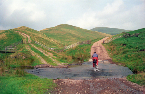
upper Coquetdale, near Uswayford

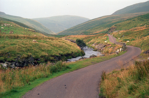
Salters Road into Breamish Valley
![]() back
back
![]() next
next
![]() home
home
![]() map and routes
map and routes