![]()
![]()
![]()
![]()
70. Wark
start: Bellingham
distance: 22 miles
OS map: 80, 87
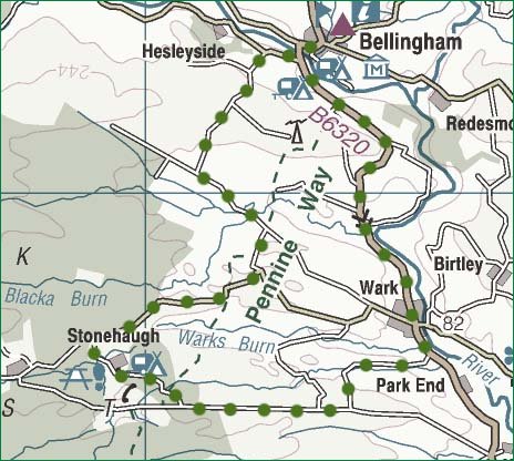 Bellingham is a pleasant village with several pubs and shops. There's a small campsite in the village and a larger one at Brown Rigg, half a mile to the south. The Pennine Way passes though Bellingham, as does the Border County Ride. There's also plenty of scope for cycling in the area. This route starts in the village and is all on road.
Take the B6320 out of Bellingham heading south for Wark. The road rises gently before dropping down to meet the River North Tyne. Wark is a mile or so further on and, though only a small place, still has three pubs.
Leaving the village, you'll soon cross the Warks Burn as it joins the North Tyne. Just a couple of hundred metres after this, take a steep road up to the R. Go R behind some farm buildings to follow the road up along the side of a wooded glen. There are some steep sections before emerging into the open. The road climbs further and as it does so you'll see the impressive skyline of Ravensheugh Crags over to the R.
Turn R at the T junction and follow along for a couple of miles or more as the road undulates. There are good open views in all directions as you approach the forestry areas ahead.
Take a turn on the R for Stonehaugh. This seems to be one of those villages built by, and for, what was then the Forestry Commission. There's a picnic area near some carved totem poles and there are several interesting walks to explore if you have time.
From the picnic area, head up to a T junction from where it's two or three miles along to Hetherington. Good views in all directions. Go through the gate on the L to head down then round to the R. The Pennine Way joins the route for a while now. Turn L at the T junction, go down to cross the stream then steeply upwards.
We're crossing open country here and you'll see a road heading off to the R to reach another high point on Ealinghamrigg Common. From this vantage point there are fine views over Bellingham. The road drops away quite steeply now so enjoy what is mostly a roll back into the town.
jb, galashiels
Download GPS data in GPX format.
![]() back
back
![]() next
next
![]() home
home
![]() map and routes
map and routes