Colorado |
Monarch Crest Trail
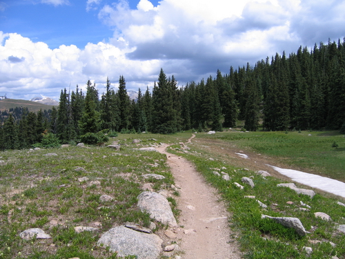
One of the images that comes to mind, of course, is that long, straight, endless road across an empty landscape. You know the one. Telegraph poles along the side of the road, that iconic yellow line disappearing towards the horizon... ...and I have to say that the utter desolation of the scene does have a certain appeal. One of the barriers to the TransAm route, of course, is getting over the Continental Divide. Fortune found Joan and I in the town of Salida, Colorado. It's a jumping-off point for a number of walks in nearby ranges - the reason we were there - and just to the east of Monarch Pass which is right on the Divide. It was here that I stumbled on references to the Monarch Crest Trail which I'd never heard of but which many reckon is among the top ten mountain biking routes in the US. It's a singletrack route starting at over 11000ft, rising up to 12000ft for about 10 miles before dropping down for almost 20 miles along an old rail bed to finish at about 7500 ft. It's all quite stunning following, as it does, the Continental Divide trail along ridges and through pine forests. Oh joy! I just had to take the plunge and went looking to see if I could hire a bike...
You can get a bike trailer ride to take you and your bike up to Monarch Pass for a little over $20 but Joan was good enough to give me a lift. In winter this is a ski area located, as it is, at 11300ft. In summer, it's just a car park and cafe stop for tourists. You can also indulge in a gondola ride which whisks you further up the mountain to take in the views. To find the MCT, though, set off along the jeep track behind the ski gondola and all the bustle is soon left behind. Look for the start of the singletrack on the right after just a couple of hundred metres or so. You're heading along the side of the lightly-wooded hillside. Enjoy this section - and you really can't fail to - but don't get too complacent because the gradient is about to change... ...and you'll soon find yourself off and pushing. Take time to admire the views of distant mountains and ridges. In fact, take as much time as you need because the effects of altitude are all too apparent if you're not acclimatised. And this climb is really the bail-out point because if you're having problems here then it's not too late to head back to the road if you have to. Once you've gained higher ground, though, and committed yourself to the trip then you're pretty well on your own. It seems to be the prevailing weather pattern in these parts that mornings can be seamless blue skies, but by midday clouds start to build and this can be the prelude to thunderstorms in the afternoon. If that's the case, then you really don't want to be out on exposed ridges sitting astride a mobile lightning conductor! In other words, it's not a bad idea to get an early start if you can and at least get off the ridges if there's any danger of a storm...
The trail undulates a little, sometimes along ridges and sometimes contouring round the hillside. Even in the middle of July there were still a few snow patches, but nothing serious. It dropped down to a col by what is known as Greens Cabin and just as I arrived, it started to rain. It was a convenient place to shelter and stop for a snack and a breather. From the cabin, the route passes through trees and then climbs gently through meadows. The rain had just about stopped but I could see storms starting to hit ridges some distance away. So the scenery, as well as being dramatic, had now taken on a menacing aura... I had no choice but to press on, of course, though on a better day I would have relished the opportunity to spend time taking in the surroundings. But not today. I was aiming for the Marshall Pass Trailhead and toot sweet! The rain held off and I'm soon at the trailhead. There are choices to be made here. You can continue a short way to Marshall Pass itself and take either the Poncha Creek Road or, if you're feeling more adventurous, the Rainbow Trail. The latter entails more climbing and more singletrack; some of which is said to be quite technical. I chose the Marshall Pass Road which is, as its name implies, the main access for the trailhead. In fact, it's an old rail bed which is now just a dirt road - the rail route is long-since closed. That said, the gradient is most amenable and, in the circumstances, I felt it was time to head down. The Rainbow Trail can wait for another time when I'm more organised - this, after all, was a real spur of the moment affair.
Turning onto the tarmac, I was a bit miffed to find the road going uphill, and some serious uphill at that! I knew this was Poncha Pass but didn't remember the route description saying that it dropped me out on the wrong side of it. It took the best part of an hour to get up to the top of the pass and I'm whacked. This really took the edge off the day and I am not a Happy Chap! No matter, there was plenty of time, I had a following breeze and I was flying down the other side of the pass into the valley. Luckily it's not a busy road and even with fairly knobbly tyres I'm still cruising along this, by now, long straight road... you know, the yellow line, the telegraph poles disappearing towards the horizon.... There's scrub either side of the road and long mountain ridges beyond - I'm having my TransAm moment! And it was a few miles before I passed a sign saying 'Highway 285 South' and even some way beyond that before it started to dawn... 285 South... SOUTH??!! Blood and sand!! I'm heading for New Mexico (only later do I discover this is the San Luis Valley). Of course, now I realise I'd turned the wrong way onto the main road. I hadn't even looked at the map because I didn't need to look at the map - I knew I had to turn right... So what to do? I was to meet Joan in a small bar in Poncha Springs. To turn around meant at least 10 miles into the wind and a long haul over Poncha Pass... not good and certainly no way to get there by 5pm. Looking around, up ahead was the first habitation I'd seen - some ranch buildings half a mile down a track. No choice, really, but to go for it.
What was the name of the bar? Of course, I didn't know. Her husband appeared. He knew the bar I meant but didn't know the name either. At this point a younger guy appeared from around the corner of the building - it turns out he's their son and also lives on the ranch with his wife and kids. Nobody knows what the bar is called... By now, I seem to have made friends with the dogs who are busy licking the salt off my legs. The elderly couple have lost their initial apprehension and are perhaps even a little apologetic that they can't be more helpful. At this point the son heads round the corner, only to return a couple of minutes later with his pickup truck and volunteers to drive me to Poncha Springs. Well I'm not going to be so churlish as to decline the offer, am I? So the interests of trans-Atlantic relations prevail, the bike is (carefully!) heaved into the back of the truck and we're on our way. There are no further problems, Joan is in Poncha Springs and the bouncy bike is returned intact and on time.
...and if any of those good folks in the San Luis Valley - you know who you are - gets to read this then, once again, my humble thanks for your help! john b, galashiels Download a .KML (Google Earth) file with the GPS data - you'll need to have Google Earth installed to view it. |
|
 Occasionally I get an urge to take the plunge and tackle one of the trans-US routes from coast to coast. It's not clear what brings this on - perhaps it's an Easy Rider sort of nostalgia thing, albeit using a more mundane and less ostentatious form of transport.
 In the event, I dropped lucky and found myself with an ex-hire (don't ask!) Ellswood fully bouncy model which had, apparently, cost $5000 when new but which was actually for sale at a knock-down $2500. At $80 for the day, how could I refuse?
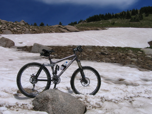 Of course, time taken in organising and picking up the bike and then driving up to Monarch Pass meant that I didn't get cycling until late morning. Blue skies sure enough, but as I set out along the higher ground the clouds were already building.
 Leaving the trailhead, then, you have some 20 miles down the dirt road to reach tarmac. On the way, the route passes through pine and then aspen forest and, although it's a road, you're unlikely to meet much in the way of traffic - an absolute delight. So it's a bit of an anticlimax to reach the main highway. I'd arranged to meet Joan in Poncha Springs, just a few miles along the road and at a prominent junction. From there it's a skoosh back to Salida.
 Having fended off the inevitable and ever-territorial farm dogs, I knocked on the nearest door. Of course, you can't get anywhere near isolated ranches like this without someone seeing you coming and I was met with suspicion by an elderly woman who inspected me through the half-opened door. I tried to explain my predicament and said that all I really needed was to get a phone message to the bar in Poncha Springs and Joan would drive out and pick me up.
 I'm left pondering the fact that a 25 mile round trip is not a trivial gesture and I'd like to think I'd be willing to do the same if the situation was reversed. I had nothing to offer in return that wouldn't seem trite or insulting except, that is, my profound thanks. That I gladly did and I'm delighted that you can still come across acts of spontaneous and unprompted generosity from complete strangers. The MCT route was superb, but maybe this was the best part of the trip, after all...